
Saginaw River turning basin near Saginaw is scraped by Muskegon dredging firm Saginaw River Depths 9 Feet Too Low Cause Dredging Emergency, Dilemma
|
||||||||||||||
| Printer Friendly Story View |
The Saginaw River in some spots is as shallow as 13 feet.
It needs to be a uniform 22 feet deep to handle large ships bringing industrial cargo to Saginaw area docks.
That nine foot discrepancy is the basic problem absorbing the Saginaw River Alliance and the U.S. Army Corps of Engineers this summer.
Standing in the way of a dredging project are the Lone Tree Council, an environmental group, Frankenlust Township officials and residents near a proposed disposal site on the river near Zilwaukee. The opponents fear harmful effects to humans from contamination from the dredged material.
A lawsuit filed by the opponents in Federal District Court in Bay City has held up construction of a Confined Disposal Facility (CDF) near the river where dredging is going on.

The issue revolves around longtime contamination of the river and bay by metals, nutrients, petroleum hydrocarbons, DDT, dioxins and PCBs (polychlorinated biphenyls) deposited due to industrial dumping and agricultural chemicals runoff. Studies show dioxin levels of 16,000 ppt (parts per trillion)in the river while recommended levels are 90 to 1,000 ppt.
A series of settlements have been reached between the U.S. Fish and Wildlife Service and Michigan Department of Environmental Quality (DEQ) and General Motors and the Dow Chemical Co. and the cities of Bay City and Saginaw to provide for substantial cleanup of river contaminations. Dioxin studies continue while Dow has established an escrow account of an indeterminate amount to pay for educational initiatives such as the recently posted warnings about consumption of fish caught in the river and bay.
Fish, wildlife and drinking water are affected by the industrial contamination, spread into the river and bay by silt and sand from the huge Saginaw River watershed, about 8,600 square miles.
Silt not only clogs the river and lowers levels but covers rock reefs in the bay in which walleye spawn, according to Michigan Department of Environmental Quality (DEQ) officials.
An additional complication is e-coli contamination from human waste emptied into the river by some smaller communities and sewage plant overflows from larger cities during rainy periods.
Despite the problems with contamination and wastewater dumping, the Bay City water supply has not been compromised because the city plant has extensive treatment capability, city officials recently reported to the Rotary Club of Bay City.
And closures of swimming beaches due to contamination have not been necessary this year, health officials have reported.
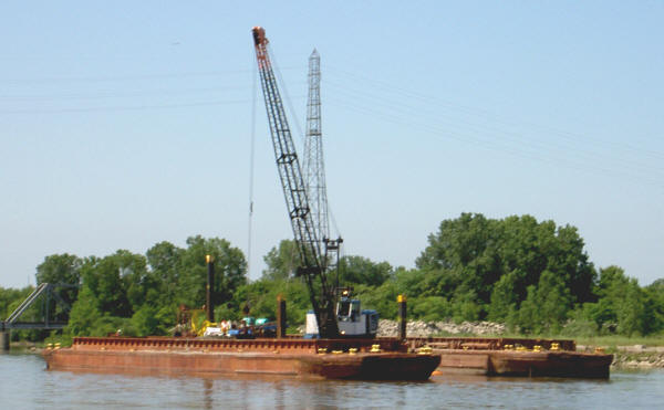
Because of the suit, the dredging firm must transport dredged spoil all the way down river to an island about a mile off shore from the Karn-Weadock Plant of Consumers Power Co.
A constant stream of barges pushed by tugs is making about 100 trips 15 miles from Saginaw to the river mouth with yellow sand from emergency dredging. Eight hour round trips by the five barges and tugs are slated to continue until completed in early September.
The Alliance is a consortium of two dozen shippers and dock operators whose operations on the river provide nearly 300 jobs and help fuel the economy of the Saginaw Valley.
Firms on the river handle four to six million tons of coal, stone, fertilizer, cement and salt every year.
Local docks could handle more if the river levels were at proper depths, business interests assert. Three of four larger lakes ships must come in less than fully loaded because of the low spots in the river.
A Muskegon firm, Great Lakes Dock & Materials, contracted by the Corps of Engineers, is dredging the Sixth Street turning basin hear the Henry Marsh Bridge in Saginaw and shuttling five barges to the disposal island in Saginaw Bay.
Once the dredged material is pumped ashore on the island, trucks must load and deposit it on the far side where there is still some room to fill. The island was reportedly completed several years ago when the search began for a new site for disposal.
The Corps of Engineers has diverted about $2 million from other projects in the Detroit district to emergency dredging of the turning basin and other low points mainly on the upper river, near Saginaw.
The work has been complicated, and made much more expensive, by court challenges by environmental groups and Bay County's Frankenlust Township to a proposed 281 acre Confined Disposal Facility (CDF) near Zilwaukee, part of which is in Frankenlust Township.
The Lone Tree Council is pressing a suit in Federal Court in Bay City to require a full environmental impact statement before proceeding with the disposal site.
Saginaw County acquired the site and is defending the suit but former Circuit Judge Lawrence M. Bielawski last January barred the Alliance from intervening.
The Alliance had argued that its business interests and $334,000 it has contributed to the project should give it standing to enter the suit.
"This case is not about the navigability of the upper Saginaw River, it is about the use of land in Frankenlust Township and about the protection of air, water and other natural resources," the judge opined.
Meanwhile, local interests are hoping Congress will respond to requests for funding to meet the 20-year dredging needs of 700,000 cubic feet and annual maintenance dredging of 200,000 cubic feet.
After 30 years of above-average water levels, the Great Lakes fell to below-average levels beginning in 1998. Lakes Huron and Michigan are down about three feet from 1997 and 20 inches from the 140-year average, according to the U.S. National Oceanic and Atmospheric Administration (NOAA).
A study last year by the Georgian Bay Association concluded that dredging and erosion in the St. Clair River near Detroit were the cause of the lower levels.
The International Joint Commission has a $14.6 million study of levels of the Upper Great Lakes underway. Results of the study may result in a recommendation of changes to the amount of water flowing out of Lake Superior, the first and largest in the chain of Great Lakes.###
| Printer Friendly Story View |
|
|
Prior Article
March 5, 2025 by: Stephen Kent St. Patricks Parade 2025 - IT's TIME |
|
Next Article
February 10, 2020 by: Rachel Reh Family Winter Fun Fest is BACC Hot Spot for 2/10/2020 |
|
|

Dave Rogers |
|
|
|
Printer-Friendly Story View
0200 Nd: 06-05-2026 d 4 cpr 0
12/31/2020 P3v3-0200-Ad.cfm
SPONSORED LINKS
12/31/2020 drop ads P3v3-0200-Ad.cfm