
Widespread Ice Cover on Great Lakes May Cause Further Hike in Water Levels
|
||||||||||||||||
| Printer Friendly Story View |
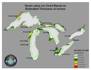
Ice cover on the Great Lakes as of Dec. 29 shows Saginaw Bay with most extensive cover.
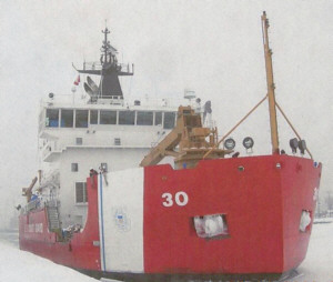
U.S. Coast Guard Cutter Mackinaw, a 240-foot seagoing buoy tender/icebreaker, stands ready at home port of Cheboygan to tackle lake ice.
Extremely cold temperatures late in December formed extensive ice cover on the Great Lakes, especially on Saginaw Bay.
But temperatures are expected to moderate and are predicted to be above normal in January and later in the first quarter of 2009.
Warmer temperatures should arrive for the upcoming weekend.
Last week temperatures near 0, with wind chill values well below 0, were common in much of the Great Lakes Basin region. To date in December, precipitation across the Great Lakes basin as a whole is above average, according to the U.S. Army Corps of Engineers.
The ice cover is expected to keep water from evaporating and help to increase water levels that already are a foot higher in Lake Huron than last year.
Lakes Michigan-Huron and St. Clair are 12 and 10 inches, respectively, higher than they were at this time last year, while Lakes Erie and Ontario are 2 and 7 inches, respectively, above last year's levels. Lake Superior is currently 3 inches above its level of a year ago.
Great Lakes water levels have undergone dramatic changes in the past decade. In the first half of 1997, levels on the upper Great Lakes were much above average. Since the late 90's, the lakes have seldom gone above their respective long term averages (LTA's).
Lake Superior set new record lows in August and September of 2007 and Lake Michigan-Huron came within several inches of its record low levels during the winter of 2007-2008. Many factors have contributed to this decline in water levels including precipitation patterns, evaporation, and snow pack.
High precipitation in September/October 2007 increased water levels on the lakes by about 6 inches when it normally fell about an inch during those months.
The light snowfall over the past ten years also has contributed to the longterm below average water levels. Snowfall in 2000, for example, was 71 percent below average. In 2007 snowfall was 40 percent below average.
Lakes Superior and Michigan-Huron are currently below chart datum and are expected to remain below datum through April. (Chart datum is a reference point determined from historical water levels. It is fixed from a 1985 zero base at Rimouski, Quebec, Canada, near the mouth of the St. Lawrence River that is approximately sea level.)
Users of the Great Lakes, connecting channels and St. Lawrence River should keep informed of current conditions before undertaking any activities that could be affected by changing water levels. Mariners should utilize navigation charts and refer to current water level readings. Ice information can be found at the National Ice Center's webpage.
Ice cover on the Great Lakes is highly variable year to- year and is a major determinant of both water quantity and quality aspects of the lakes.
Studies are underway on the climatologic variability of ice cover on the Great Lakes and correlations with lake level highs and lows. Without ice cover, evaporation can occur and lower water levels on the Great Lakes.
Many of the main rivers in the Great Lakes also are subject to ice control measures to limit damage and keep waterways ice-free. Some of these methods include ice booms and ice breaking. Extensive ice breaking is now occurring in Canadian waters.
Ice cover on the Great Lakes is highly dynamic, which challenges ice researchers and resource managers. New studies are underway to improve the understanding of the processes of ice formation, break-up and control.
Ice cover was severely limited on all of the Great Lakes 1998-2007. Unseasonably mild winter throughout the Great Lakes basin was the cause of this phenomenon. The lack of heavy ice cover was believed to be the reason for lower water levels on the lakes.
During the winter of 2001-02 ice formed only on protected bays and shallow inlets.###
| Printer Friendly Story View |
|
|
Prior Article
March 5, 2025 by: Stephen Kent St. Patricks Parade 2025 - IT's TIME |
|
Next Article
February 10, 2020 by: Rachel Reh Family Winter Fun Fest is BACC Hot Spot for 2/10/2020 |
"The BUZZ" - Read Feedback From Readers! |
|
seppa Says:
On February 04, 2010
at 02:07 PM
Do you know of any chart for the great lakes that is similar to this one for ice-cover? Any help appreciated! Thanks!!!
http://www.ijis.iarc.uaf.edu/en/home/seaice_extent.htm |
|
|

Dave Rogers |
|
|
|
Printer-Friendly Story View
0200 Nd: 06-05-2026 d 4 cpr 0
12/31/2020 P3v3-0200-Ad.cfm
SPONSORED LINKS
12/31/2020 drop ads P3v3-0200-Ad.cfm