
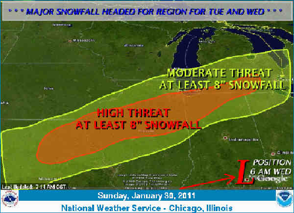
Map issued by U.S. Weather Service, Chicago, shows heavy snow predicted to sweep across mid-Michigan beginning Tuesday night. WEATHER UPDATE -- Take Care Digging Out, Wind Chills 10 Below Predicted
January 31, 2011
Leave a Comment
|
||||||||||||||
| Printer Friendly Story View |
UPDATE FROM U.S. WEATHER SERVICE, THURSDAY, FEB. 3 -- 8 A.M.
Today ...Mostly sunny. Areas of blowing and drifting snow. Highs 19 to 23. Southwest winds 10 to 20 mph.
Tonight...Mostly clear...becoming partly cloudy toward daybreak. Blustery. Lows 5 to 9 above...with wind chills around 10 below. Southwest winds 15 to 25 mph...diminishing to 10 to 20 mph.
Friday...Partly sunny. Highs 22 to 26. Southwest winds 10 to 20 mph.
Friday Night...Partly cloudy. A slight chance of light snow showers. Lows 12 to 16. Southwest winds 10 to 15 mph. Chance of snow 20 percent.
YOU CAN OBTAIN YOUR LATEST NATIONAL WEATHER SERVICE FORECASTS ONLINE AT WWW.WEATHER.GOV/DETROIT (ALL LOWER CASE).
Saturday...Mostly cloudy. A chance of light snow showers. Highs 27 to 31. Southwest winds 5 to 15 mph. Chance of snow 30 percent.
Saturday Night...Mostly cloudy. A slight chance of snow showers. Lows 19 to 23. Chance of snow 20 percent.
Sunday...Mostly cloudy. A chance of snow showers. Highs 28 to 32. Chance of snow 30 percent.
Sunday Night...Mostly cloudy. A chance of snow. Lows 15 to 19. Chance of snow 40 percent.
Monday...Cloudy. A chance of snow. Highs 28 to 32. Chance of snow 40 percent.
Monday Night...Cloudy. A chance of snow. Lows 4 to 8 above. Chance of snow 40 percent.
Tuesday...Mostly cloudy. A chance of snow. Highs 14 to 18. Chance of snow 40 percent.
Tuesday Night...Partly cloudy. A chance of snow showers. Lows 4 to 8 above. Chance of snow 30 percent.
Wednesday...Mostly cloudy. A chance of snow showers. Highs 12 to 16. Chance of snow 30 percent.
LONG TERM...WEDNESDAY NIGHT THROUGH NEXT TUESDAY
RESIDUAL NORTHERN STREAM MID LEVEL TROUGHING WILL BE LEFT BEHIND IN THE WAKE OF THE WINTER STORM FOR THE WEDNESDAY NIGHT/THURSDAY PERIOD...AS THE MAMMOTH HIGH PRESSURE SYSTEM SPRAWLS EAST- NORTHEASTWARD FROM THE SOUTHERN PLAINS INTO THE OHIO VALLEY. A PIECE OF THE ARCTIC AIRMASS NOW PENETRATING SOUTHWARD DOWN THE FRONT RANGE OF THE ROCKIES AND INTO THE PLAINS WILL WORK EASTWARD... ALTHOUGH NOT NEARLY TO THE DEGREE NOTED UPSTREAM /925 MB HOLD WITHIN THE -10 TO -12C RANGE/.
| Printer Friendly Story View |
|
|
Prior Article
March 5, 2025 by: Stephen Kent St. Patricks Parade 2025 - IT's TIME |

|
Next Article
February 10, 2020 by: Rachel Reh Family Winter Fun Fest is BACC Hot Spot for 2/10/2020 |
|
|

Dave Rogers |
|
|
|
Printer-Friendly Story View
0200 Nd: 06-05-2026 d 4 cpr 0
12/31/2020 P3v3-0200-Ad.cfm
SPONSORED LINKS
12/31/2020 drop ads P3v3-0200-Ad.cfm