
BAY COUNTY IN 3-D: Commission Aims Aerial Cameras to Boost GIS Program
April 4, 2015
Leave a Comment
|
||||||||||
| Printer Friendly Story View |
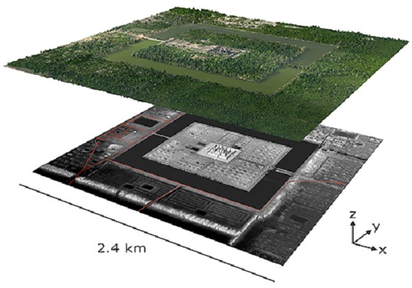
An example of digital orthophoto mapping, with elevations, by Digital/World Mapping, Inc.
Bay County this spring will take a better look at its territory from the air.
The vehicle will be aerial photography, but not just any old aerial photos will be acquired.
This $57,000 project will secure digital orthophotography, with LiDAR flight to boot.
LiDAR, which stands for Light Detection and Ranging, is a remote sensing method that uses light in the form of a pulsed laser to measure ranges (variable distances) to the Earth, technicians explain.
Why do we need this project? Commissioner Kim Coonan, chairman of the ways and means committee, explains: "LiDAR data can be used to support drain district mapping, road engineering, 3D modeling, site development, coastal zone management and flood plain mapping."
The data should have a shelf life of up to 20 years and won't require updating every five years like orthophotography.
These light pulses -- combined with other data recorded by the airborne system -- generate precise, three-dimensional information about the shape of the Earth and its surface characteristics.
A LIDAR instrument principally consists of a laser, a scanner, and a specialized GPS receiver. Airplanes and helicopters are the most commonly used platforms for acquiring LiDAR data over broad areas.
Two types of LiDAR are topographic and bathymetric. Topographic LiDAR typically uses a near-infrared laser to map the land, while bathymetric lidar uses water-penetrating green light to also measure seafloor and riverbed elevations.
LiDAR systems allow scientists and mapping professionals to examine both natural and man-made environments with accuracy, precision, and flexibility. NOAA scientists are using LiDAR to produce more accurate shoreline maps, make digital elevation models for use in geographic information systems, to assist in emergency response operations, and in many other applications.
LiDAR data sets for many coastal areas can be downloaded from NOAA's Office for Coastal Management Digital Coast web portal.
###
| Printer Friendly Story View |


|
|

Dave Rogers |
|
|
|
Printer-Friendly Story View
0200 Nd: 04-19-2024 d 4 cpr 0
12/31/2020 P3v3-0200-Ad.cfm
SPONSORED LINKS
12/31/2020 drop ads P3v3-0200-Ad.cfm