Charges of Excessive Draining of Lakes Michigan/Huron Refuted by Army Corps
March Check of Snowpack to Verify Predictions of 10 Inch Rise in Lake Level
February 20, 2005
By: Dave Rogers
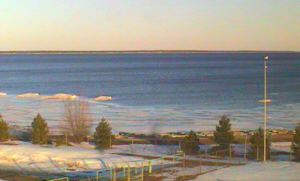
Great Lakes Environmental Research Laboratory webcam photo at Thunder Bay, Alpena, shows exposed rocks from low water.
A Canadian study charges that the levels of Lakes Michigan and Huron are permanently lower because they are being drained by dredging.
The Army Corps of Engineers in Detroit responds by asserting that the level of Lake Erie and the earth's crust are rising, making it appear that lakes Michigan/Huron are falling.
The National Wildlife Federation and Great Lakes United, two environmental organizations, have jumped to the support of the Canadian study.
"You can't fool Mother Nature," says Tim Eder, NWF director of water resources.
"We can't keep digging deeper channels for navigation without serious repercussions for the people and wildlife who depend on Great Lakes waters."
The South Bend Tribune recently called for an end to "excessive draining of Lakes Michigan and Huron into Lake Erie."
Alarms were raised by the report of a six month study by W.F. Baird & Associates Coastal Engineers for the Georgian Bay Association Foundation, a registered Canadian charity representing 4,000 families living on the bay.
The report charges that shoreline alteration, riverbed mining and navigation dredging have eroded the bottom of the St. Clair River and resulted in the permanent and continuing lowering of water levels on Lakes Michigan and Huron.
The U.S. Army Corps of Engineers fires back that there's no excessive draining, asserting that the earth's crust is still rebounding fromthe weight of the glaciers millions of years ago. Because the earth is higher, the lakes just appear to be lower, the Army Corps Detroit office stated recently.
"The Georgian Bay area has one of the highest rebound rates in the basin, ranging from 7 to 12 inches per century," states an Army Corps news release. "This has an impact where the current water level meets the shoreline. As the earth's crust is rising, the water level appears to be receding, when in fact it may not be."
"Lakes Superior and Ontario have control structures to manage lake levels under a variety of climate conditions," states the Baird study. "There are no such control structures for Lakes Michigan and Huron. Once the water is gone, it is gone."
The Baird study states that it has taken into account fluctuations in precipitation and the effects of glacial rebound.
Predictions of a 10 inch rise in Great Lakes water levels will be verified, or revised, in March, when the National Weather Service makes its annual check of the snow pack in the Lake Superior drainage basin.
Last year the snow pack was 40 percent higher than average, causing all of the lakes to rise at near normal rates last spring, according to the U.S. Army Corps of Engineers.
Rising lake levels also were helped by extremely heavy rain during the spring.
However, lake levels remained below their long term averages throughout 2004, causing hand-wringing and complaining among economic interests and the media around the lakes.
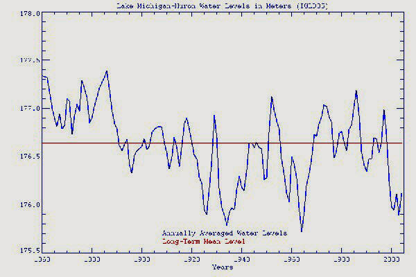
Water level chart by National Oceanic and Atmospheric Administration
shows historic water levels on Lake Huron.